
Adventure in the Ansel Adams Wilderness
- Veronica & Brett
- Nov 7, 2021
- 15 min read
Updated: Nov 21, 2024
Overview
Date: 22 July – 25 July, 2021
Location: Ansel Adams Wilderness, Inyo National Forest
Entry point: Rush Creek trailhead, near June Lake, California
Total distance: 33.5 miles (54 kilometres)
Elevation gain: 6,560 feet (2,000 metres)
Highlights: Banner Peak looking majestic af over Thousand Island Lake, alpine lake swimming, breathtaking sunset, Marie Lake, bivying without the tarp
Summary: A four-day, three-night adventure in the Ansel Adams Wilderness, with dramatic views and lots of skinny dipping

Trip log:
After experiencing the beauty of Sabrina Basin, I wasn't sure anything would be able to compare. I was wrong. The vistas we saw in the Ansel Adams Wilderness were just as awe inspiring. (Warning: this is a decently long blog post, I won't judge you if you just skim through to look at the pictures!)
On Thursday the 22nd of July, we set out from our hostel in Bishop at 6:30 in the morning, heading north to the June Lake Loop, where we would be starting our second trip in the Sierras. For this trip, Brett and I were joined by Mitchell, one of Brett's friends from his time at UCSB. Due to COVID-19, Brett and Mitchell hadn't seen each other in person since December 2019, so they were excited to get this chance to go on an adventure together before they hiked a stretch of the Sierra High Route later in the summer.
Day 1: Rush Creek Trailhead to Thousand Island Lake // 10 miles (16 kilometres)
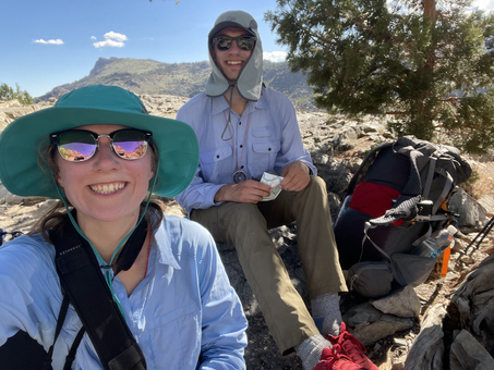
Brett and I arrived at the Rush Creek trailhead at 7:30 and were ready to start our hike an hour later. The heat was already heavy, and we faced a brutal climb of 1,900 feet (580 metres) before we would reach Mitchell (who had entered the wilderness the previous day). Traversing the south-facing slope meant the sun was beating down on us the whole climb, and with little relief from shade, we were soon drenched with sweat. We took short breaks under the few trees we passed, pausing to catch our breaths and drink water. It quickly became apparent why Mitchell had suggested we do this part of the trail as early in the morning as possible…


Two things surprised us on this first stretch of the trail:
The path crossed incredibly steep tram tracks, twice. The Agnew Tramway was constructed in 1915 to build and service the dams in the valleys above. Looking down as the track fell steeply towards the valley below made me a little dizzy, but done carefully, the crossings weren’t too scary.
There were horses on the trail! How they manage to walk on these rocky, narrow and steep paths still amazes us. We learnt later that you can pay for horses to bring your hiking gear up to campsites at higher elevations, so you don’t have to carry it up that miserable first climb.


We had a break under a tree at Agnew Lake before continuing to climb to the next dam, following painful switchbacks up the hill until we met up with Mitchell. From there, the trail followed the edge of Gem Lake, a dammed lake. After the heat of the morning, we were happy to be in the shade of the trees.

We stopped for lunch on a beach at the edge of Gem Lake. It was there that we went for our first of many swims on this trip (Mitchell skinny dipped while Brett and I still wore our swimsuits). Afterwards, we dried off in the sun as we cooked and ate our fanciest meal of the trip – scrambled tofu with red onion, vegan sausages and ketchup, all served up in a wrap. Delicious!


Over the next few hours, we hiked through the forest, crossing rivers and passing a number of smaller lakes along the way.


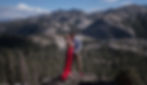
The panoramic views from Agnew Pass were outstanding and I enjoyed shooting some self-portraits in my red dress with the valley spread out behind me. While I was taking pictures, Brett and Mitchell were identifying the lakes in the valley below us, comparing Brett's printed maps with Mitchell's phone maps.


It was at Agnew Pass that we met one of many extraordinary people we met on this trip – an older woman who was finishing her final stretch of the Pacific Crest Trail (PCT), which she was completing in sections. Over six years, she had hiked the majority of the 2,650-mile (4,260-kilometre) trail – the section in the Sierras was the final section that she needed to complete.


From Agnew Pass, we followed the PCT until we reached our destination for the day. The trail snaked through forests and the lack of variation in the trees made it feel like we had been walking forever. While taking a snack break, we heard a waterfall, so leaving our bags by the side of the trail, we went exploring. We were rewarded with a lovely view of the river crashing through the forest. We knew we must be getting close to Thousand Island Lake.
As the trail emerged from the forest, we suddenly had a view of Banner Peak over a small pond. It was by far the most photogenic mountain I’d ever seen. (As you’ll be able to tell from the enormous number of photos featuring Banner Peak in this blog post…).


From there, it was just a short walk along the river before our end destination was finally in sight. Thousand Island Lake spread out in front of us, with Banner Peak rising up in the distance.
As we got to the junction between the PCT and the John Muir Trail (JMT), we met another spectacular human being who was attempting to run the entirety of the JMT in just four days! For reference, it took Mitchell 21 days to finish the 211-mile (340-kilometre) hike, which is a pretty average time. To finish in four days, this guy was seriously moving! (But not going nearly as fast François D'Haene, who in 2017 set the record for fastest supported time on the JMT, completing the trail in *under* three days!!).

Anyways. We arrived at Thousand Island Lake around 19:00. It was too cold to swim, so we decided to keep walking until we found a campsite. After the quiet of Sabrina Basin, the shores of Thousand Island Lake felt crowded, with lots of tents already pitched. We were worried all of the good campsites would already be taken, but were delighted when we stumbled across a flat ledge elevated just off the lakeshore. With amazing views out over the lake and towards Banner Peak, it was the perfect campsite.


As we cooked mac n’ cheese for dinner, the sky began to come alive with colour. The clouds were strokes of pink and orange, painted across a vibrant blue sky. Across the lake, we watched as the moon rose through a bed of pink clouds.


As the colours continued to get more vibrant, Brett and I took as many pictures as we could on as many cameras as we had.

With no rain in the forecast, we decided to bivy camp that night, meaning we had no tarp to hinder our view of the sky above us! Our ledge was the perfect size for all three of us to lay out our bivys next to one another. Before heading to sleep, Brett and I set up our film cameras to take more moon trail shots. When we got up at midnight to start the shutters, we were amazed at how still the water on the lake was. The full moon cast a soft light over everything and was bright enough to read by (probably…I didn’t try…it was midnight, I went back to sleep).


After a wonderful first day in the Ansel Adams Wilderness, we were excited that over the next two days we wouldn’t have to drive or spend any money - rarities for us when traveling in the US. For the first time on our trip, we were going to have a full day completely submerged in nature.
Day 2: Thousand Island Lake loop via Garnet Pass // 7.8 miles (12.5 kilometres)
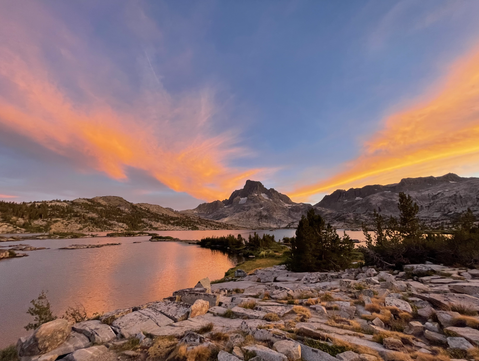
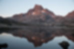
Our second day began with another early start to take pictures of sunrise. The water of Thousand Island Lake was completely still, offering beautiful reflections of Banner Peak and the surrounding mountains. After wandering down to the peninsula by our campsite, I was happy when the sun peeked out from behind the wildfire smoke for a minute, bathing Banner Peak in a warm pink glow.
Exhausted, I crawled back into my sleeping bag and went back to bed. An hour later, the sun was shining directly on my bivy and I began to feel uncomfortably warm and claustrophobic. Extracting myself from my sleeping bag, I joined Brett and Mitchell at the edge of our campsite, admiring the view over the lake.
With the sun shining above us, Brett and I braved the cold of the morning to swim in the calm waters. We swam out to some small islands and then to the peninsula, where we walked back to our campsite. At this point, I’ll answer the question I know you’re wondering. Are there really 1,000 islands on Thousand Island Lake? Unfortunately, no. Brett estimated the number was probably closer to 100, but the false advertising didn't take away from our amazement at the size and grandeur of the vast lake.
I was shivering by the time we got back to our campsite. Wrapped in our sleeping bags, we cooked breakfast: instant porridge with dried mango and cranberries. As we ate, we decided what to do for the day. We had planned on going to Minaret Lake, but after three full-on days of hiking, I didn't think I could manage such a long trek. Instead, we agreed that we would explore the area around Thousand Island Lake. The previous evening we had spotted a dark part on the cliffs above us. Our curiosity piqued, we decided to spend the morning hiking towards the feature to figure out what it was. We didn’t want to lose our perfect campsite, so we decided to leave our bear canisters and other things behind when we left. It also meant that I didn’t have to carry a backpack for the day, which was lush!

We followed the trail around towards the top of Thousand Island Lake, before leaving the path and pointing our feet up toward the dark part of the mountain. At one point we heard a distant rockfall somewhere above us, and I found myself, yet again, terrified. Mitchell’s advice of “if a rockfall is going to kill me, there’s not much I can do about it” didn’t exactly put me at ease. We couldn't see any movement in the mountains above us, so we continued our hike.


From the higher elevation, we had a wonderful view of Thousand Island Lake stretched out below us. The landscape was dotted with boulders and trees, with small streams cutting across the hill. Brett and I stripped down for a very short dip in a small waterfall pool. The water felt freezing (which makes sense considering it was glacial melt).


As the mountains loomed large in front of us, it became clear what the dark patch was. Brett had guessed right; a waterfall was making the rock wet, darkening the stone. Brett and Mitchell decided to practice hiking on a talus field (according to Brett, talus is “big ass boulders”). While they practiced with their backpacks, I took some self-portraits at a waterfall I had found nearby. We ate lunch in the shade of a large tree. A fairly disappointing pre-made spinach dahl, served with rice in, you guessed it…wraps.

Having accomplished our goal for the day, we headed back to the shore of Thousand Island Lake and made our way towards Garnet pass, a backcountry route leading towards Garnet Lake. On the way, Brett ran up to touch a small glacier and we walked through some very marshy land next to the lake. I was a little nervous about tackling the talus field on Garnet pass, but without a backpack it wasn’t that scary.


We stopped to recover from the climb next to a tarn above Garnet Lake. The water was beautiful and clear, so Brett and I couldn’t resist going for another swim. The water was very shallow, meaning it felt incredibly warm compared to the stream we’d swum in earlier.


From there, we were aiming to go to another pass to get back to Thousand Island Lake. Brett and Mitchell convinced me we should “contour” across the slope towards this pass, but after coming across talus fields, dense forests and cliffs, we ultimately agreed it would be quickest to descend to the shore of Garnet Lake, where we could follow a maintained trail.

At the shore of Garnet Lake, we discovered a beautiful cove, where we went for our fourth and final swim of the day. The water felt refreshing and Brett convinced me that we should swim out to a little island.


It was beginning to get late into the afternoon, and I was concerned we would be walking back to our campsite in the dark. Instead of going all the way back to the JMT, we took a less managed trail over the ridge. We stopped for a few minutes to talk to a ranger and she informed us that the trail used to be part of the old JMT.
I was relieved that our bags were still there when we got back to our campsite! We had dehydrated camping food for dinner. The beans and rice combo was not nearly as exciting as the Pad Thai we’d had at Moonlight Falls. No exciting sunset that evening, so after agreeing on our plans for the following day, we headed to bed.
Day 3: Thousand Island Lake to Marie Lake and Waugh Lake // 14 miles (22.5 kilometres)
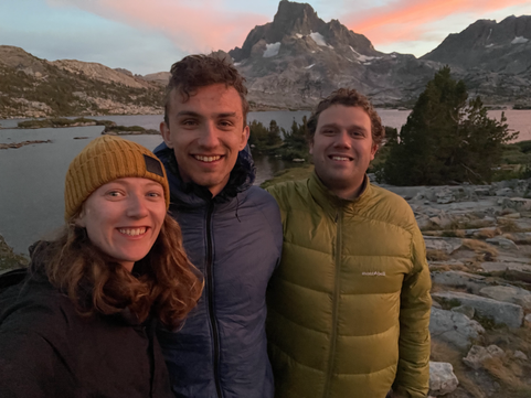
Brett and I got up early (once again) to take pictures of sunrise. We packed up our campsite in the dark and wandered down the river at the outflow of the lake. We were pleased to see that the sky was clear of smoke, meaning that the rising sun cast a warm glow on Banner Peak. Fighting the mosquitoes, we managed to get some great shots of the mountain with the river in the foreground. The photo on the right was taken on my film camera.


After a fantastic morning photography session, we walked back towards the lake, where we met up with Mitchell. I couldn't resist getting a self portrait of the three of us with Banner Peak in the background. It was time to start the day!

We started off hiking over Island Pass, following the JMT. The climb was a difficult way to start the morning, but we felt relieved it wasn’t too hot out yet. Plus, the expansive views over Thousand Island Lake made every second of the climb worth it.


Saying goodbye to the lake, the pass took us through forested areas. We stopped for breakfast on a huge rock near the saddle of the pass. As we ate our porridge, Mitchell read to us from Steve Roper’s book about hiking the Sierra High Route. After breakfast, I saw my first marmot. Marmots are the "heaviest members of the squirrel family" and are incredibly cute.


We followed the JMT until we reached the junction to Waugh Lake. We crossed the river and rested for awhile, letting our gear dry before leaving our bags and beginning the hike up to Marie Lakes. To begin with, we continued to follow the JMT. We found a waterfall just off the path, and I ended up going for a quick skinny dip in the natural pool at the foot of the waterfall. While hiking, we (unsurprisingly) ran into a lot of people hiking the JMT, who Mitchell loved talking to, comparing experiences and offering advice. One couple stood out in my mind – an older couple from Washington who were hiking the JMT in week-long sections each year, giving them the time to do little excursions off the main trail to explore other areas of the Sierras. We aspire to still be as adventurous when we’re their age.


At the next junction, we turned left, breaking away from the JMT and heading onto the Marie Lakes Trail. After a lot of switchbacks, we arrived in an incredibly lush valley, filled with streams and dotted with boulders. As far as we could see, we had the whole valley to ourselves. From there, we followed an unmaintained trail up to the lakes. It went through the talus, steep at times, but I was pleased we could stick to the trail and avoid rock scrambling. We were shocked to pass a glacier on our way up, and we made a quick detour off the path to touch the frozen sheet of ice.


At 12:30, we caught our first glimpse of Lower Marie Lake. In the distance, we could see a waterfall tumbling down from Upper Marie Lake, and above that, the glacier that was feeding the lakes. Marie Lakes provided a stark contrast to the lakes we’d seen up until this point. Above the treeline, the lake was surrounded instead by rocks, creating a dramatic and imposing environment. It felt like we were in Iceland.

We walked down to the shore of the lake, where Mitchell found a perfect rock to jump into the water. Unsurprisingly, it was freezing cold. Brett and I swam out to a small island. Unlike most of the other swims on the trip, the water felt painfully cold and I became acutely aware of parts of my body that I can’t normally feel...


Lunch was jackfruit curry, which we ate quickly. Dark clouds were forming above us, and after our first experience with lightning in the mountains, I was very certain I didn’t want to be in such an exposed area if there was a storm. We hiked back down to the valley where Brett and I went looking for somewhere to swim in one of the many small waterfalls. Not finding anywhere suitable, I didn’t go in. To cool off, Brett dipped his shirt in the water, but when he was about to put it back on, we noticed it was covered in small black dots, which we think were small leeches. We spent the next ten minutes picking them all off of his shirt with our fingers. Feeling relieved we hadn’t swum, we walked back down the valley, where we joined Mitchell who was chilling on top of a boulder the size of a small house. We sat and chatted, enjoying the peace of the empty valley.
Eventually, we dragged ourselves off the boulder and followed the winding path back down towards our bags. On the way, we passed a ranger who asked for our permits – it was Mitchell’s first time ever being asked for a permit while in the wilderness! The rain started as we were walking down, and it was coming down hard by the time we picked up the rest of our bags at the junction. We followed the trail through the forests around Waugh Lake, passing good camping spots, but with the rain still falling, we were hesitant to stop and set up camp. We reasoned that the more we hiked that evening, the less we’d have to do the following morning to get out of the wilderness, and therefore, the earlier we could get to Yosemite. We agreed that we would find somewhere at the bottom of Waugh Lake to camp for the night.


We prepared our dinner in the protection of some tall trees. That night’s meal – Kathmandu Curry – would need half an hour before it could be eaten, so instead of sitting around waiting for it to rehydrate, we poured in the boiling water and then continued hiking. We stopped to eat on a rocky outcropping with panoramic views out over Waugh Lake and the surrounding mountains. It was amazing to see how far we had come from the mountains near Marie Lakes. Luckily, the rain had stopped, and the sun even peeked out from behind the clouds, casting a magical glow over the forest on the other side of the lake.

We passed the dam at the bottom of Waugh Lake and began the hunt for a campsite. The path turned a corner and we were suddenly being devoured by hundreds of mosquitoes. Thankfully, with my rain gear on, most of my skin was covered and, therefore, protected to some extent from the evil of mosquito bites. The only part that was uncovered were my hands and when I looked down, there were at least 5 mosquitoes on each hand. I was in my personal hell. In an attempt to prevent the mosquitoes from being able to land on my hands, I walked waving my hands in front of my face – it must have been quite a sight. Unable to take it anymore, we stopped for the boys to get out their bug nets and for me to apply Deet to my hands. Unfortunately, we stopped in the worst possible spot, because just 100 metres later and the number of mosquitoes was suddenly more manageable.
We pushed on for another hour, desperate to find a campsite that was not haunted by the shrill whine of hundreds of mosquitoes. Eventually we found somewhere far enough from the riverbank and not too exposed to the elements. Exhausted from our longest day of hiking, we set up camp and were asleep soon afterwards.

Day 4: Gem Lake to Rush Creek Trailhead // 5.5 miles (9 kilometres)
On our last day of this adventure, we slept in till 6 (quite the lie in for us…), packed up our gear and then began the trek back to Rush Creek. Once again, we stopped at the beach at Gem Lake, this time to eat breakfast and go for another swim. Brett inflated Mitchell’s sleeping mat and brought it into the lake to use as a pool floatie. He was having so much fun that Mitchell and I both had a go as well. We had a blast paddling around in the sun! Pro tip: don’t attempt this with your sleeping mat unless it’s an air pad (i.e. it’s fully inflatable and doesn’t have any foam in it). We lay the mat out in the sun to dry as we cooked lunch.


The stretch from Agnew back to Silver Lake was almost as awful going down as it was on the way up. We were still hot and sweaty, plus we ended up hiking behind a group of annoying men who wouldn’t let anyone overtake them…
We arrived back to the parking lot at 11:30, sad that this adventure had come to an end, but also desperately ready to get into an air-conditioned car. We packed everything up and drove to Mammoth Lakes, a popular ski resort just south of the June Lake Loop. Brett and Mitchell were craving post-hike burgers, so we stopped at the Mammoth Brewing Company for lunch. Afterwards, we got ice cream before saying goodbye to Mitchell. We agreed to meet up in the Bay Area when Brett and I arrived the following week. And then all that was left to do was resupply and head out for our next trip. Onwards to Yosemite Valley!
I feel very fortunate to have experienced the beauty of nature in such a spectacular environment. I just want to finish this blog post with a quote from Ansel Adams (the photographer for whom the wilderness area was named), that still feels relevant today.
"It is horrifying that we have to fight our own government to save the environment." - Ansel Adams
Resources:
Trail map: https://www.alltrails.com/explore/map/camping-trip-2-thousand-island-lake-2b6d65b?u=m
Wilderness permits: https://www.recreation.gov/permits/233262
Ansel Adams Wilderness: https://www.fs.usda.gov/recarea/inyo/recarea/?recid=21874
Rush Creek trail information: http://www.fs.usda.gov/goto/inyo/rushcreektrail
June Lake Area trail map: https://www.fs.usda.gov/Internet/FSE_DOCUMENTS/stelprdb5337623.pdf
Land acknowledgement: We acknowledge that we were hiking on the traditional land of the Me-Wuk (Central Sierra Miwok), Western Mono/Monache and Numu (Northern Paiute) peoples.
Find out whose land you are on by visiting https://native-land.ca/. To learn more about Indigenous people in the Sierra Nevada, here are some resources we have found interesting:
A People's History of the Sierra Nevada: https://www.sierraclub.org/sierra/2016-4-july-august/americas-national-parks/people-s-history-sierra-nevada