
An autumn hike to Big Pine Lakes: The ultimate photography road trip on Highway 395 (Part 3)
- Veronica & Brett

- Feb 26, 2024
- 7 min read
Updated: Oct 2, 2025
Overview:
Date: 14 November 2023
Location: John Muir Wilderness, in the Eastern Sierra Nevadas, California
Total distance: 15.2 kilometres (9.4 miles)
Elevation gain: 730 metres (2,395 feet)
Highlights: Relaxing in the sunshine on the shore of First Lake, views of Temple Crag, having the whole wilderness (almost) to ourselves
Summary: A chilly hike through forested mountainside to stunning glacial lakes

Trip log:
This is the third of four posts about our road trip along California's scenic Highway 395 last autumn. Our hike to Big Pine Lakes follows on from our adventures in Death Valley and Alabama Hills, which you can read about in earlier posts. With an extra day to spare from leaving Death Valley early, we yearned to hike in the Eastern Sierra and re-experience the magic of our US hiking trips in 2021.
On the sixth day of our road trip, after driving back to Big Pine from the Ancient Bristlecone Pine Forest, we sat in the parking lot of the gas station, scrolling through many blog posts, trying to find a hike for the following day. We settled on a 10-mile hike along the Big Pine Creek North Fork trail. The trailhead was close to our campsite and blog posts raved about its incredible views. We picked up a Tom Harrison map of the area at the gas station, so we felt ready for our hike!
Day 7 // Big Pine Lake loop
When our alarm went off at 4:30, I was relieved it was time to get up – sleeping next to a highway with a constant stream of semi-trucks isn’t exactly conducive to a good night’s sleep. We packed up our tent in the dark and began the 20-minute drive up to the Big Pine Creek Trailhead.

Apparently, this is a very popular trail in the summer and camping permits can be hard to come by, so many people opt to explore the Big Pine Lakes on a day hike. The trail passes multiple stunning alpine lakes, but with limited hours of daylight, we knew we wouldn't be able to complete the full hike. Instead, we aimed to get to Second Lake, which – from photos online – looked like the most dramatic of the lakes.
Travelling in the off season, we weren't surprised to see we were the only car in the small parking lot when we arrived at 7:00. The temperature was below freezing, so we ate our snacks in the car in an attempt to stay warm. As we stumbled out into the cold to pack our bags for the day, the mountain tops were illuminated with the first rays of warm light. We had to get going soon to ensure we'd return before dark.

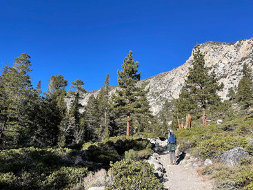
By 7:15, we were on the trail, following a river and climbing up into the Sierras. I found the first mile of the hike the hardest – the elevation gain and the constant switchbacks made it hard for me to breathe. Starting at 7,800 feet (2,380 metres) elevation, we had a long climb ahead of us if we were going to reach Second Lake at 10,120 feet (3,080 metres).


After crossing the river a second time, the trail split. We opted to take the upper fork, as it appeared to involve a more gradual climb in elevation. As the rising sun peaked out from behind the mountains, the trail was bathed in light. We quickly warmed up and stripped off some layers. We were, perhaps, a little hasty, as we were soon back in the shade of a forest and back pulling on additional layers.


As the trail wound its way around the edge of the valley, we could see Second Falls through the trees. As we had seen at Whitney Portal, the waterfall was semi-frozen. The trail continued to climb, once again following the river as it weaves through the landscape. Although we were a few weeks too late in the season to see the vibrant autumn colours of the aspen trees we passed, the mountain was still full of colour thanks to the pine trees and many shrubs lining the path.


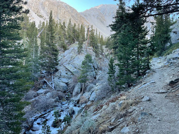


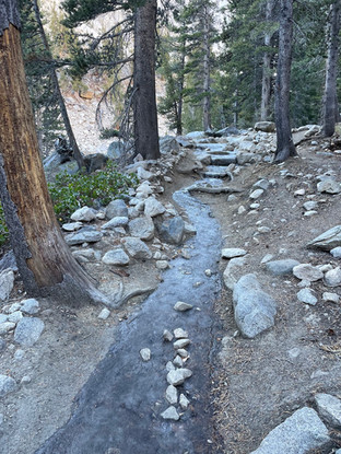
As we continued upwards, the cold was never far from our minds. Despite consistently climbing elevation, we were still wrapped up in multiple layers to stay warm. It felt funny to be wearing both a sunhat and two pairs of gloves! Before setting off, we'd agreed that if the trail got too dangerous, we would turn around. Luckily, although there were points where ice covered the path, it was always easy enough to avoid it.


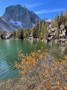
As we approached First Lake (creative name, I know), we left the trail and wandered through the forest down to the lakeshore, the turquoise waters sparkling through the trees. I've read a few blog posts that recommend you skip First Lake and continue onwards to Second Lake, but we would disagree. This was our favourite spot on the whole hike.

We rested on the lakeshore, admiring the fall colours and dramatic face of Temple Crag rising above us. After the crowds in Death Valley, what a joy it was to have this whole place to ourselves. I briefly entertained the thought of going for a swim, but was worried I wouldn't be able to warm up again, so ultimately decided against it.


We were determined to make it to Second Lake, so after resting for awhile in the sunshine, we left the calm beauty of First Lake and continued upwards. As the trail climbed, we were rewarded with another beautiful view out over First Lake.


Within half an hour, we had arrived at a viewpoint overlooking Second Lake, with incredible views of the surrounding mountains and of the imposing face of Temple Crag. We enjoyed the view, but both agreed we preferred First Lake – the water levels at Second Lake were low and the rocky shoreline wasn't as picturesque as the tree-lined shore of First Lake.


Although the lighting conditions weren't ideal, Brett set up his large format camera to take a shot of Temple Crag (yes, he carried all his camera gear up the mountain with him!). I love this picture of Brett with his large format camera – one day when he has a photography book, I hope he uses this in the introduction.


The hike had sapped my energy and I felt physically drained (perhaps not eating a full breakfast isn't a good idea when you're about to do an intense hike in the cold). Luckily lunch – cold lentil stew on bagels – and a short nap seemed to revive me somewhat. While I napped, Brett consulted the Tom Harrison map to identify whether it was possible to cross country around Temple Crag. Despite sitting in the sun, the cold was beginning to take hold, which was when we knew it was time to turn around and begin the hike back down the mountain.


Although we were only halfway through our hike, I was encouraged by the fact that going down would be easier and quicker than the journey up. We followed the same route we'd taken to get up to the lakes. At one point, Brett enjoyed strapping his microspikes onto his shoes so he could practice walking on one of the icy stretches of path.
As we were on our way down, we finally ran into other hikers, for the first time that day! We chatted with a couple who became full-time travellers when their son went off to university – what a dream! They told us about the months they had spent exploring Europe in a van and recommended some hot springs to check out nearby. We offered some advice about places to visit in the UK on their next visit before waving goodbye and continuing down.


At the trail split, we took the lower fork this time, which stayed closer to the river. I couldn’t help but admire the large pine cones (Brett was less impressed – the pine tree at his house makes pine cones just as large).


We made it back to the car by 15:00, almost seven hours after setting off in the morning. What an adventure! As we drove back down to join Highway 395, we stopped once more so I could take some pictures of the autumn colours.


Post-hike
Back on Highway 395, we drove north from Big Pine to Bishop. We stopped at the ranger station to ask about places to camp that night. Brett also picked up an impressive book that details how to traverse all the peaks and passes in the Sierra Nevada mountains (he tells me that it's an excellent resource to procrastinate writing a PhD thesis!). Apparently there's still a peak that hasn't been summited yet, but the author won't reveal that secret to make sure there's still some mystery in the Sierra Nevadas.
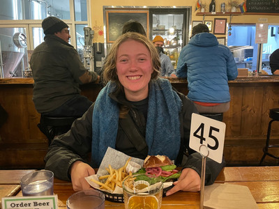
After visiting the ranger station, we drove to the Bishop Gear Exchange, an outdoor store selling new and used gear. As Brett was trying on sun hoodies, I crashed. Hard. We were inside and I had all of my layers on, but I couldn't stop shivering. I lay on the couch, entirely sapped of energy. I could tell that I needed food, and soon. We agreed to eat dinner at Mountain Ramblers (where we had eaten back in 2021 after our first hike in the Sierras). The burgers were fantastic and the warmth was very appreciated after feeling cold for most of the day! Unfortunately, they didn't have hot chocolate (it is a brewery, after all), but some tea helped stop my shivering. We even splurged and got dessert! After nights of simple meals cooked on a camping stove, it was such a treat to have a proper meal.


Neither of us particularly fancied going back out into the cold – in fact, I was dreading it – and we briefly entertained the thought of getting a hotel for the night. But our desire to save money was stronger than our desire to sleep in a warm bed #PhDstudentlife. So, after visiting another gear store, we drove out to the Pleasant Valley Pit Campground, a few miles outside of Bishop. We found a pitch and paid $3 at the entrance kiosk, but the campground was so large that we couldn't find the toilets in the dark without a map! By 20:30 we were wrapped up warm in our tent, exhausted and ready for bed.

The final post from our trip will be coming soon, so keep your eyes open for that! And thanks, as always, for reading!
Resources
Trail map: https://www.alltrails.com/explore/map/map-december-18-2023-f5a14d4
Official trail map: https://www.fs.usda.gov/Internet/FSE_DOCUMENTS/stelprdb5337640.pdf
Information from the Forest Service: https://www.fs.usda.gov/recarea/inyo/recreation/recarea/?recid=20328&actid=50
Permits for overnight use: https://www.recreation.gov/permits/233262


Comments