
Reconnecting with friends on the Sierra High Route
- Brett

- Jan 17, 2022
- 15 min read
“The timberline country of California’s Sierra Nevada is dominated in summertime by five elements: meadowlands, gnarled trees, water, stone, and a cobalt sky occasionally augmented by towering cumulus clouds. In this austere landscape, backpackers who travel along the Sierra High Route—a rugged alternative to the John Muir Trail—can forget the outside world and concentrate solely on moving from one pristine campsite to another.”
~ Steve Roper, creator of the Sierra High Route
Overview
Date: 7-13 August, 2021
Locations: Sabrina Basin, Sierra Crest, Evolution Basin, Glacier Divide, Humphreys Basin, Pine Creek
Entry point: Lake Sabrina trailhead, near Bishop, California
Exit point: Pine Creek trailhead, near Bishop, California
Summary: A week-long off-trail adventure on the Sierra High Route with old friends. We stayed above 10,000 feet and resided among the granite peaks, the alpine lakes, and of course, the marmots.

Trip log:
Introduction
As time passes and the paths of friends diverge, what can reunite us? My university friends—Anoop, Dolev, Mitchell, and Nick—and I pondered this question. We decided that the Sierra High Route, a 195-mile traverse through the subalpine region of the Sierra Nevada, was the answer. This adventure had the potential to reunite us, year after year. The problem solving and presence of mind demanded by the High Route appealed to us, the navigational and physical challenges would give us the opportunity to grow together. The summer of 2021 was the best time to reunite and embark on our maiden adventure.
The High Route routinely passes through serene meadowlands, expansive basins, and imposing mountain passes in an effort to remain in the most beautiful region of the High Sierra—its timberline country. In doing so, the route avoids the mass of hikers on the John Muir Trail and offers a challenging traverse of the Sierra Nevada. The High Route is not an actual trail, rather, it is a series of landmarks—it is the hiker’s job to chart a course from one landmark to the next. Steve Roper, the creator of the High Route and its associated guide book, describes the route without spoiling the immersive experience of route finding—only the salient features of the route are described. We did our best to follow in Roper's footsteps. What follows is a day-by-day description of our seven-day hike of the “Whitebark” section of the Sierra High Route.

The eagle
Nick, our “eye in the sky” was busy preparing for his wedding and so wasn’t able to join us (the nerve!). But, he resided with us in spirit as he was our primary contact with the outside world and gave us daily weather updates via satellite communication.
Day 1: Hiking up the smoky Sabrina Lake Basin
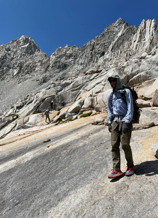
Normally, the towering Eastern Sierra mountains dominate the skyline of Bishop, which lies 8,000 feet below the peaks. But when we—Dolev, Anoop, Mitchell, and I—arrived to pack our gear, the mountains were shrouded ominously in smoke and we couldn’t see them. Although the fire was 100 miles away, it produced enough smoke to make it hard to breathe in the valley. We worried that our trip might be over before it even began!
We decided to at least give the hike a shot and hoped that the smoke would clear higher up. So, without clear knowledge of what lay ahead, we entered the mountains and drove to the Sabrina Lake trailhead (9,138 ft).
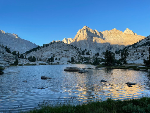
Even at that elevation, the smoke lingered, but as we gained altitude and the aspen trees gave way to pine trees, the smoke began to clear. Yes! There was hope for our trip to continue. Two hours later, we took our first break at Blue Lake (10,400 ft). The glacier-fed water was frigid, but that didn’t stop us from jumping in (and quickly getting out!). We continued our trek, powering our way up the basin until we stopped at the meadow preceding Moonlight Lake (11,070 ft) at sunset.
(A quick note on the photos included in this blog post...I was shooting 35mm film on my Olympus camera throughout our trip, so in addition to my film shots, many of the photos included here were taken by Anoop on his phone. Thanks Anoop for letting me share them!)


We set up camp, tired from our first day hiking at altitude, but we stayed awake until complete darkness so we could marvel at the stars. Look up long enough and there it is—a shooting star! And look there’s another one! When it’s that dark, even the Milky Way is visible. In fact, it was almost startling to see how many stars there are in the night sky.
Day 2: The challenge of traversing Echo Col
We broke camp at sunrise and hiked around Moonlight Lake, passing through a meadow that looked straight out of a fairytale. We hiked to Echo Lake (11,600 ft), the last lake in the Sabrina Lake Basin. This lake was close enough to its glacier source that we could drink the water without filtering it. Refreshing indeed!

Now we had to hike around Echo Lake and continue up and over the Sierra Crest, the set of mountains that divides the easily accessible frontcountry from the more remote backcountry. The hiking trail ended here, marking the point where the High Route begins. Now we had to rely on Roper’s guide. We quickly realised how Roper omitted needless details and expected the hiker to figure out how to get from A to B. For example, he described our first day of off-trail navigation in only three sentences. There would be no hand holding on this adventure! A map, a compass, a GPS, and a good sense of direction were essential for a successful trip (i.e. not getting lost).

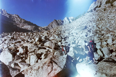
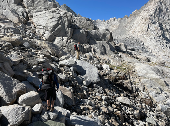
We left the trails behind to enter the land of large boulders and steep slopes. Here, as we traversed around Echo Lake, we encountered talus, “variously sized boulders, sharp edged and stacked like dominoes,” according to Roper. On flat terrain, talus is relatively stable, but on steep terrain, traversing talus turns into a game of Jenga, where the consequences of tumbling rocks cause heightened nerves at best and fatal injury at worst.

After rounding the lake, we had to hike up and around a glacier, and then ascend another 800 vertical feet through steep and sometimes crumbly talus to Echo Col (12,400 ft), a 20-foot wide notch in the Sierra Crest and the only way to get into the backcountry without a rope and harness in tow. We realised we were in for a day of hard hiking and bouldering and that made us nervous. None of us had ever attempted anything like this before.
We hiked up the talus fields, but sometimes the viable path was so narrow that we had to hike in single file, and sometimes the talus was so loose that we had to stagger ourselves to avoid any potential rockfalls from the ascending hiker. We were inexperienced, so we triggered more small rockfalls and we slipped more than we would like to admit.


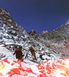


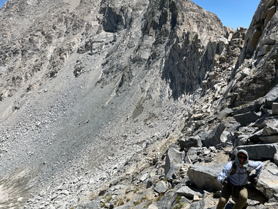

We slowly ascended the mountain in this haphazard manner, nervously eying the precarious rocks above us and the steep descent below us. It didn’t help that we could hear distant rockfalls, which reinforced the precarious situation we felt we were in. As we approached Echo Col, the Class 2 hiking (scrambling without requiring hands for stability) turned into Class 3 hiking (scrambling with hands and potential for falling) and our pace slowed. With 100 feet left, we sometimes had to take our backpacks off and pass them to the hiker above us. Relieved, we eventually cleared Echo Col. At the top we could see the Sabrina Basin behind us, and the Ionian Basin and Black Giant (13,330 ft) ahead of us.

We were mentally exhausted at Echo Col after hours of constant anxiety and intense concentration, but luckily the descent was easier. We descended around 1,000 feet to an unnamed lake which we named ‘Dehydration Lake’ because it was a hot and sunny day, and Dolev was experiencing some mild heat exhaustion and dehydration. We rested at this lake for several hours, enjoying the cool water and taking some time to mentally recharge. After Dolev had recovered, we hiked along the lake shore and camped along a ridge that overlooked the John Muir Trail, another 500 feet below.


We didn’t stay up to watch the stars that night; we were tired and needed our sleep. But I did manage to take an eight hour exposure of the stars streaking across the night sky. The wonder of film photography! Of course, you will probably notice the streaks of red and blue light in some of the photos. Those streaks come from unwanted sunlight finding its way into my camera. The woes of film photography.

Day 3: Hiking on the Hiker’s Highway to Darwin’s Bench
We departed again at sunrise and we had a 500-foot descent from our ridge to the John Muir Trail below us. Although this was just day 3, we could already tell that our skills of manoeuvring through endless talus fields were improving. We learned how to visually judge which rocks and boulders were stable which meant we didn’t have to test as many footholds and start as many rockfalls. We also learned how to judge our “lines”—the path of least resistance through a boulder field or down a mountain—so now we avoided the steepest slopes and loosest talus.

With our improving skills and increasing confidence, we quickly descended the 500 feet. And this time we were able to enjoy the view! Black Giant dominated the landscape, but thankfully our route led us to the more serene valley below.

As we approached the John Muir Trail, we began to see other hikers, our first contact with anyone else in 36 hours. The John Muir Trail is the hiker’s highway. We hiked along it for the majority of the day and we saw a hiker almost every 10 minutes. What a difference the presence of a trail and other hikers make! We could let our guard down for a bit. And we couldn’t help but tell other hikers, “See those mountains and boulder fields off in the distance? That’s where we came from.”
Just as highways facilitate high speeds for driving, the John Muir Trail facilitates high speeds (relatively speaking) for hiking. We passed Helen Lake, Muir Pass, Wanda Lake, Sapphire Lake and Evolution Basin and swam many times, all before lunch. Evolution Basin was magnificent. It was a flat-as-a-pancake, walk-in-the-park hike with in-your-face views of Mt Mendel (13,710 ft) and Mt Darwin (13,831 ft). You might also notice, like we did, that the mountains, lakes, rivers, and meadows in a given area had names centred around a common theme—evolutionary scientists for instance.

At Evolution Lake we took an extended lunch break and traded stories with a fellow hiker who impressed us with their world travels and spontaneity. After lunch, we had to decide where to eventually cross Glacier Divide, another towering set of granite mountains and our next all-day traverse. We could follow the High Route to Snow Tongue Pass, which was apparently even harder and more dangerous than clearing Echo Col. Roper’s book shared an anecdote of one of the first attempts at Snow Tongue Pass: “James Hutchinson was aghast as he gazed over this cliff in 1904, noting with gloom that ‘the prospects were far from bright.’” Sounds appealing, right? Or, we could take the easier alternative, Alpine Col, which Roper described as “relatively straightforward and well-travelled.” Although our skills were improving, they weren’t improving quickly enough, and we couldn’t trust our luck to take us over the mountain. So, it was an easy decision: go with the easier Alpine Col, which offers similar views without decreasing your life expectancy to get there.
We had to “stage” for our ascent of Alpine Col, that is, to hike and camp as close as we could to the Col, so we could traverse it first thing the next morning to avoid afternoon thunderstorms. We hiked further into Evolution Valley, before making a 90 degree turn to leave the John Muir Trail and ascend to Darwin Bench, another meadowland that looks straight out of a fairytale with its ample waterfalls, rivers, vibrantly coloured wildflowers, granite, and crystal clear reflections off the lakes.


We took a rest at Darwin Bench to address Anoop’s bloody nose. Luckily it was a quick fix and we ascended further to some unnamed lakes around 11,400 ft. With the light fading, we set up camp. At this point, my shirt had a couple of serious tears in it and Mitchell taught me how to sew them up. I felt like I had unlocked a new superpower! But it was just another day for Mitchell.
We were tired after all the elevation and the miles, so after admiring the progress we had made thus far, we fell asleep soon after nightfall.
Day 4: Traversing Alpine Col and calling for help
We left our campsite first thing in the morning to hike past two unnamed lakes. We were in a bowl shaped region, surrounded by boulder fields and granite mountains on all sides. The landscape offered a minimal palette of bluebird skies, steel grey granite, and lakes somewhere in between. Despite the water, there was no plant life here. This desolate wilderness made us feel small and insignificant, but that made us rely on and trust each other even more. We were fulfilling the goals of our trip!


We hiked past one final lake and arrived at the base of Alpine Col. We had a 500-foot ascent that we did with ease. Anoop led the charge and could direct us through the talus with increasing confidence, “Avoid the triangular rock, it’s loose. See that rock around hip level? It’s stable and serves as a foothold. Eventually we’ll work our way around this rock face to avoid the wash.”


At the top of Alpine Col (12,400 ft), we could see the bowl-like basin we left behind and the flat Humphrey’s Basin awaiting us. To our right lay Muriel Peak (12,937 ft). After lunch we met some fellow hikers doing a similar route, but headed in the opposite direction. We could teach each other what lay in store.


Here was the plan: Dolev and Mitchell would descend to Goethe Lake (11,530 ft) while Anoop and I would quickly ascend Muriel Peak without packs, come back to Alpine Col, and then descend to Goethe Lake. Mitchell and Dolev would arrive at the lake first, where they would wait for us. If Anoop and I failed to reach them by 7 pm, then Mitchell would call for help using his Garmin, a satellite communication device and our only means of contacting the outside world.
Anoop and I quickly ascended the peak without our packs. In places we could almost run up the mountain. Most of it was easy scrambling, but there was a little bit of exposure (i.e. a few places where a fall, though unlikely, could prove fatal) at the very top. From there, we could see minty green lakes and turquoise blue lakes, both of which come from minerals in glacial melt. The view was impressive, but a sudden burst of cold gave us the impression that humans weren’t meant to perch on precarious peaks for long. Message received.


In less than two hours, we hiked back down Alpine Col and to our destination of Goethe Lake. But where were Mitchell and Dolev?
There’s no way we could have passed them, they went straight to Goethe Lake. We waited for 30 minutes but grew worried and restless. We explored the surrounding area and came across another hiker. She loaned us her Garmin to send a concerned (if ominous sounding) message to Nick to let him know we were okay, but that we were looking for Dolev and Mitchell, and that if we didn’t find them then we would exit the wilderness to fetch for more help. After another endless hour of waiting, there they were, off in the distance! How did we beat them? Turns out they had taken an ill-advised detour around the far side of the lake. Phew! Anoop and I were relieved, but Mitchell and Dolev had no sense anything was amiss! We laughed off the incident, but we learned how important it is for every party to have a communication device.


We were all mentally and physically exhausted so we camped right then and there. We swam, traded stories and jokes, and looked again to the stars. I tried another star trail photo, which entailed setting up the camera in the dark, exposing the film for eight hours, and then waking up at 4 am to end the exposure before the march of morning light.

Day 5: Lounging in Humphrey’s Basin
The delay from our slow traverse of Echo Col and our miscommunication at Goethe Lake meant we were a day behind schedule. We now had a decision to make. Do we stick with our original itinerary, which at our slower place would make the trip 9 days? Or do we cut off the last leg of the trip and shorten it to 7 days? We didn’t have a full 9 days of food and the insatiable hikers hunger was beginning to set in. We decided to shorten things up and relax a bit.
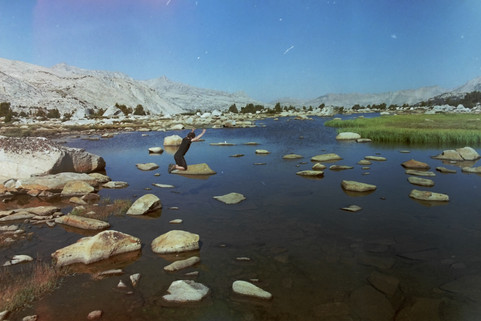
Our vacation destination was Humphrey’s Basin, a flat and grassy plain dotted with boulders, meadows, and lakes. We quickly descended into the basin and had a whole day to swim in lakes and lounge about, and that’s exactly what we did! We found a marshy lake with large flat rocks and thought it fun to jump from one to the next. Call us childish, but when we were in nature even the simple things gave us joy.


We idled across Humphrey’s basin and stopped at Desolation Lake (11,400 ft), where we enjoyed many hours of swimming, talking, and even napping. Mitchell showed Dolev how his inflatable sleeping pad can be used as a makeshift raft. Thunderstorms threatened, so we took caution because Humphrey’s Peak (13,986 ft) loomed ominously to the right and rumour has it that it attracts an inordinate amount of lightning, even for the Sierra Nevada. Luckily the clouds turned out to be all bark and no bite.

We continued to Mesa Lake and then to a marsh above the lake. We found a pile of boulders to practice our bouldering skills and the wide open space meant we could throw a frisbee. We even hiked to the top of a hill and succumbed to the child-like impulse of throwing the frisbee as far as we could. Unfortunately (but perhaps not surprisingly), we lost the frisbee. We searched for an hour but to no avail. May it rest in peace.
We had plenty of time to idle and solve the world’s problems over dinner. We talked late into the night, pondering the personal, the pedestrian, and the profound.
Day 6: Traversing Puppet Pass and relaxing like the French
Six days in and we had survived the hardest parts of the hike, but there were still new challenges. Dolev had a rough night of nose bleeds and stomach aches, but when the sun rose he managed to get out of bed like the rest of us. This was characteristic of Dolev—he tends to join adventures at the last minute, not knowing what he’s getting himself into—and yet he’s able to persevere through the many unexpected obstacles he seems to attract. That’s why we called him the wildcard!
Our last and easiest traverse was Puppet Pass. We hiked up in about an hour and we still had energy so we climbed the nearby peak to get a panoramic view of mountains in every direction.

We sped down the peak and descended into the French Lakes region, which included Alsace Lake, Paris Lake, Lormaine, Blanc, Petite, La Tete, and French Lakes. Oh mon Dieu! But before we knew it, we had finished our last traverse. We felt like quite the experienced adventurers!

Remarkably, this was the first day we started talking Physics, if you can believe it. That’s quite an accomplishment for a group of physicists! I especially enjoyed those conversations because they brought me back to our group’s time together at UCSB.
The rest of our hiking was relatively uneventful and lazy so I’ll spare the details. As we approached civilisation, we finished our off-trail portion of the adventure and returned to the manicured trails characteristic of the Sierra. We descended quickly with such an easy path to follow. It was our first time dipping below 10,000 feet in 6 days, and with this descent came the return of hikers, mosquitos, and dammed lakes. Humans weren’t meant to stay in paradise forever, and it was our time to return to Earth.
We camped along Birchim Lake which had a nice view of Bear Creek Spire (13,713 ft). Besides the view, the campsite lacked the grandeur and isolation we had grown used to. There were ants, mosquitos, and signs of human activity. I had trouble sleeping so I looked at the sky long enough to count over 100 shooting stars. You read that right—100!
Day 7: Hiking down Pine Creek and returning to civilisation

We were eager to return to civilisation so we made quick work of our final six miles. We passed Birchim Lake and more and more hikers to reach the trailhead. After changing into our first pair of clean clothes in a week, we began to feel like human beings again.
How much did the world change during our absence? Did the US experience another rise in covid cases? Or did we make it to a post-covid world? How were our loved ones? Our phones divined the answers as we gained cell reception for the first time in a week. Ping! One phone would go off. Ping! Another. Messages and notifications came flooding in and we knew we were back in civilisation.
We picked up our second car and boy were we hungry! We honoured the tradition of getting burgers at the Mountain Rambler Brewing Company in Bishop. You might think that we’d stand out with our matted hair and accumulated smells of the wilderness, but we fit right in with the other hikers that flock to this brewery. After our delicious meal, Anoop drove back to San Diego while Dolev, Mitchell, and I drove to San Francisco, but not before getting another burger along the way!
Conclusion
Our goal was to do something that would motivate our friend group to reunite and continue to build our relationships post-university. Did we succeed? Absolutely! The trials of travelling through endless talus fields, navigating through the backcountry, and miscommunications required us to rely on each other. And the easier, second half of the trip gave us time to relax, to catch up on each other’s lives and learn where each of us were headed. This was an empowering trip because it wouldn’t have been successful without each and every person’s contributions—together we were more than the sum of our parts.
Postscript: The Wedding
We couldn’t have come up with a better way to strengthen our friendships. That is, until we attended Nick’s wedding in San Diego a week later. We reassembled to serve as Nick’s groomsmen and watched him marry his fiancee, Megan. It was a day filled with beauty and love. It was the perfect way to cap a summer of adventures.

Resources:
(Rough) trip map: https://www.alltrails.com/explore/map/map-january-2-2022-6-52-pm-141aa4f
Must-have guide book: Sierra High Route: Traversing Timberline Country by Steve Roper: https://bookshop.org/books/sierra-high-route-traversing-timberline-country-2nd-edition/9780898865066
Wilderness permits: https://www.recreation.gov/permits/233262
Land acknowledgement: We acknowledge that we were hiking on the traditional land of the Eastern Mono/Monache and the Numu (Northern Paiute) people.
Find out whose land you are on by visiting https://native-land.ca/. To learn more about Indigenous people in the Sierra Nevada, we recommend A People’s History of the Sierra Nevada.

Great write up, thank you!! What a fun adventure! Do you by chance remember seeing any place for a solo backpacker to camp at Echo Lake? I'm not sure I'm going to go over Echo Col yet, but I'd like to make it to Echo Lake for some rainbow trout fishing before continuing my planned route.